
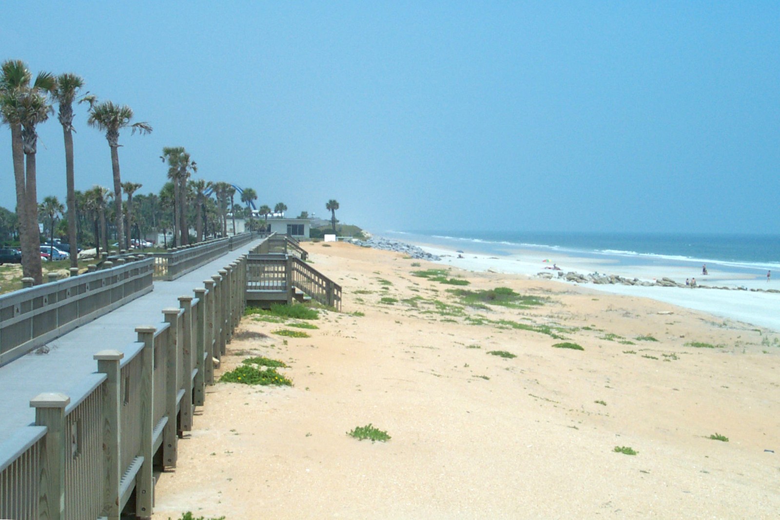
Flagler County Coast · Florida
Marineland
- State
- Florida
- County
- Flagler County
- City / community
- Marineland
Marineland is an incorporated town in Flagler County.
Northeast Florida · Flagler County Coast
Marineland is the northernmost named Flagler County shoreline in this publication. Its approximately R-1 to R-4.6 extent carries a documented boundary-precision caveat.
Good fit: A quiet, coquina-lined Atlantic shoreline around Marineland and River to Sea Preserve.
Plan around: Choose your entrance before setting off: facilities and restrictions vary along the shoreline.
- Parking
- Limited preserve parking
Details & sources
Limited preserve parkingDetails & restrictionsFlagler County · River to Sea Preserve ↗ - Dogs
- Yes
Details & sources
Leashed dogs welcome
The official destination guide identifies Marineland-area public accesses as dog-friendly. Keep dogs leashed and remove waste.
Palm Coast and the Flagler Beaches · visitor FAQ ↗ - Restrooms
- Yes
Details & sources
At River to Sea Preserve
The county lists restrooms at the preserve; facilities are not promised at every shoreline approach.
Flagler County · River to Sea Preserve ↗ - Lifeguards
- Unknown · clarification pending
Details & sources
Lifeguard coverage not confirmed
No fixed lifeguard station is listed for River to Sea Preserve. Enter only when conditions suit your ability and check current warnings.
Flagler County · River to Sea Preserve ↗ - Key restrictions
- Check before you go
Details & sources
Use signed routes, leash pets, remove waste and leave dunes, wildlife and rock formations undisturbed. Follow posted water-quality notices.
Flagler County · River to Sea Preserve ↗ - Best for
- See beach overview
Beach overview
A quiet, coquina-lined Atlantic shoreline around Marineland and River to Sea Preserve.
Sources & review dates
More planning facts: access, driving & fees
- Public access
- Public accessDetails & restrictions
- Beach driving
- NoDetails & restrictions
- Accessibility
- Public beach access at River to SeaDetails & restrictions
Choose an entrance
Limited preserve parking. Check the route and parking details below, then choose an entrance in the county directory.
Parking, route & accessibility evidence
Parking & entry: Limited preserve parking. Use the signed River to Sea Preserve parking areas on A1A; capacity is limited and roadside parking is not a substitute.
Parking source ↗Accessibility: Public beach access at River to Sea. The preserve provides a public route across A1A to a coquina shoreline. Check current facility notices before travel.
Accessibility source ↗Open the county entrance directory ↗
Use the directory to check each entrance’s identity and status. Guide map pins are approximate shoreline locations, not turn-by-turn entrance directions or proof of current opening.
Rules & facilities
Check before you go
Swimming flag: no dated location-specific official flag report is connected for this guide. Do not infer a flag from the regional rip-current forecast; verify flags and signs on arrival.
Closures and access: check Flagler County beach information for the named access, managing park or city. A countywide notice is not automatically beach-specific.
Water quality: the nearest same-county Florida Healthy Beaches station, distance disclosure and dated sample appear in Conditions & activities as dated saved results and refresh from the verified snapshot when available. A nearby station is context, not a sample taken at this beach.
Forecast context: the NWS surf-zone forecast and NOAA tide prediction in that section are regional planning tools, not current water measurements or permission to enter.
Compare Northeast Florida beach dog rules ↗
Browse verified Flagler County beach accesses ↗
What to bring & supporting visit details
Plan your visit
Getting from the car to the coast, and what to bring. Nearby services are distinguished from facilities at this beach.
Shade & picnic areasBring personal sun protection
No beach-wide promise of shade is made. Use a listed pavilion only where the beach page identifies one, and expect the open sand to be unshaded.
Palm Coast and the Flagler Beaches · beach guide ↗Drinking waterBring drinking water
No beach-wide bottle-refill service is listed. Bring potable water; showers and restroom sinks are not presented as refill stations.
Palm Coast and the Flagler Beaches · beach guide ↗Concessions & suppliesNearby dining; no on-beach concession assumed
Use the sourced dining listings below and confirm current hours. A nearby restaurant is not an on-site beach concession.
Listed nearby dining: Captain’s BBQ at Bing’s Landing. See Food & drink nearby below for locations and official links.
Palm Coast and the Flagler Beaches · beach guide ↗Beach chairs & umbrellasArea operators; confirm exact access
The activity and rental listings below identify verified operators. Confirm delivery, meeting point, beach permissions and pickup for this exact access before booking.
Palm Coast and the Flagler Beaches · beach guide ↗Cell servicePlan for patchy reception
Reliable, recent carrier-specific reception at this beach has not been verified. Check your carrier or the FCC mobile map for this location; modeled coverage is not a beach signal test. Save your route and access instructions offline before visiting.
FCC · How to use mobile coverage maps ↗Reviewed September 29, 2026. Unknown means unverified, not absent. Distances are published reference values where stated, not a current route survey. Services and equipment availability can change. Rental links are unpaid; no affiliate commission is included.
Public or private?
Public access
Who can visit: Open to the general public, including visitors, during permitted hours and subject to posted rules.
Entry route, fees & access boundaries
- Manager / access authority
- Flagler County
- Access basis
- This listing covers a publicly managed beach access or park, not a private guest-only beach.
- Where to enter
- Use the signed River to Sea Preserve beach route across A1A.
- Fees & reservations
- Public access does not establish free parking. See Parking & entry for the researched fee information.
- Restrictions & exceptions
- Use the preserve entrance and designated route. The accepted Marineland boundary caveat and adjacent property ownership remain separate from this public-access finding.
- What this label covers
- The documented public beach entrance at River to Sea Preserve within the Marineland parent shoreline; not every approach or adjacent parcel.
Beach ownership, the route across land, public shoreline-use rights and access to facilities are separate questions. Rules vary by state and location. Use the identified public entrance or documented permission; neither a nearby resort nor an admission fee by itself establishes that a beach is private. A mapped beach is not permission to cross private property.
Access policy reviewed 2026-09-28. Not a live closure report or a property-boundary survey.
Allowed & prohibited activities
Rules for this beach. Campgrounds, restaurants and picnic areas may have different permissions.
- Alcohol
- With restrictionsPersonal use allowed · restrictions apply
The official destination FAQ allows individual alcohol use on the beach, while large parties require an event permit. Glass, intoxication laws and stricter posted rules still apply; Flagler Beach separately prohibits alcohol on its boardwalk and pier.
- Bonfires & beach fires
- With restrictionsPermit and seasonal rules
Beach fires require authorization and are prohibited May 1 through October 31. County-owned natural lands also prohibit igniting fires without prior approval.
- Beach camping
- Not allowedNo ordinary overnight beach camping
Use a designated campground or reserved campsite. A beachfront campground is not permission to camp on an adjoining public shoreline.
- Shore fishing
- With restrictionsShore fishing is a documented beach use
Flagler County promotes surf fishing at its beachfront parks. Carry the required Florida license unless exempt, obey posted zones and keep hooks clear of swimmers.
Shore fishing: licenses & responsible casting
Unless exempt, you need the appropriate Florida saltwater fishing license even when fishing from shore. Eligible Florida residents can obtain a no-cost shoreline license; nonresidents need a nonresident saltwater license unless an exemption applies. A license does not override local closures or swimming-area restrictions.
Check FWC’s current species, size, season and bag limits. Targeting sharks from shore has additional permit and gear requirements. Keep hooks and lines away from swimmers and wildlife, and take discarded tackle home.
Rules reviewed 2026-09-22. Check official notices for temporary closures and burn bans before your visit. Other access, pet and driving rules appear below.
- Hours
- County park: dawn – 11 p.m.
River to Sea Preserve lists daily dawn-to-11 p.m. hours. Other approaches may post different hours.
Flagler County · River to Sea Preserve ↗ - Dogs on the beach
- Leashed dogs welcome
The official destination guide identifies Marineland-area public accesses as dog-friendly. Keep dogs leashed and remove waste.
Palm Coast and the Flagler Beaches · visitor FAQ ↗ - Lifeguards
- Lifeguard coverage not confirmed
No fixed lifeguard station is listed for River to Sea Preserve. Enter only when conditions suit your ability and check current warnings.
Flagler County · River to Sea Preserve ↗ - Restrooms
- At River to Sea Preserve
The county lists restrooms at the preserve; facilities are not promised at every shoreline approach.
Flagler County · River to Sea Preserve ↗ - Access & beach rules
- Protect the preserve and coquina shoreline
Use signed routes, leash pets, remove waste and leave dunes, wildlife and rock formations undisturbed. Follow posted water-quality notices.
Flagler County · River to Sea Preserve ↗ - Beach driving
- No public beach driving
Use signed pedestrian access points; no public drive-on route is provided.
Flagler County · River to Sea Preserve ↗
Conditions & activities Surf, sand, wildlife and suitability
Conditions at the beach
Saved reports below are dated snapshots, not live conditions. JavaScript refreshes them from official sources when available. Source timestamps and tide times identify their time zone.
Weather observation
Saved report · not live. This dated snapshot may be out of date. Check the official source before your visit.
70°F · Light Rain
- Flagler County Airport · nearby reporting station, not a beach sensor.
Observation: 2026-11-20T09:55:00+00:00.
Retrieved: 2026-11-20T10:57:56.909Z.
Live-use expiration: 2026-11-20T11:55:00.000Z. This static copy never certifies current conditions.
UV forecast
No current-hour UV estimate is shown in this saved page. Use sun protection; the live forecast loads when available.
Daily forecast
Saved report · not live. This dated snapshot may be out of date. Check the official source before your visit.
Saved forecast for this beach’s NWS grid
- 2026-11-20T03:00:00-05:00–2026-11-20T06:00:00-05:00: Overnight · 70°F · Rain Showers Likely · wind 23 mph NE
- 2026-11-20T06:00:00-05:00–2026-11-20T18:00:00-05:00: Friday · 72°F · Rain Showers · wind 21 to 28 mph NE
Source issued/updated: 2026-11-20T06:21:21+00:00.
Retrieved: 2026-11-20T10:57:57.083Z.
Live-use expiration: 2026-11-20T11:00:00.000Z. This static copy never certifies current conditions.
High & low tides
Saved prediction · not live. This dated snapshot may be out of date. Check the official source before your visit.
Smith Creek · Flagler Beach. Nearby tidal reference; Atlantic timing and heights can differ from the inland creek station. Predictions, not measured water levels or safe crossing times.
- 2026-11-20 03:04 · Low tide
- 2026-11-20 08:59 · High tide
- 2026-11-20 15:34 · Low tide
- 2026-11-20 21:22 · High tide
- 2026-11-21 03:53 · Low tide
- 2026-11-21 09:55 · High tide
- 2026-11-21 16:32 · Low tide
- 2026-11-21 22:17 · High tide
Prediction dates: 2026-11-20–2026-11-21 · station local time.
Retrieved: 2026-11-20T10:57:56.987Z.
Live-use expiration: 2026-11-21T10:57:56.987Z. This static copy never certifies current conditions.
Smith Creek · Flagler Beach. Nearby tidal reference; Atlantic timing and heights can differ from the inland creek station. Predictions, not measured water levels or safe crossing times.
NOAA tide station ↗NOAA swim & rip-current forecast
Saved report · not live. This dated snapshot may be out of date. Check the official source before your visit.
Forecast rip-current risk: High · Coastal Flagler Beaches
- Surf: 8 to 9 feet.
- Breezy. Northeast winds 20 to 25 mph.
- Cloudy. Showers.
- Forecast risk is not an observed beach flag.
Source issued/updated: 11/20/2026 500 AM EST · Today.
Retrieved: 2026-11-20T10:57:54.724Z.
Live-use expiration: 2026-11-21T00:00:00.000Z. This static copy never certifies current conditions.
Forecast risk is not the flag flying at this beach. Conditions can vary within the forecast area.
Official local flag & condition status
Flag color: not currently verified
No location-specific official flag feed is connected. Check Flagler County and the managing city or park for closures, then verify posted flags and signs on arrival.
The Beach Database does not convert weather or a rip-current forecast into a colored flag. Check flags and signs on arrival and ask a lifeguard where available.
Weather warnings & alerts
Saved report · not live. This dated snapshot may be out of date. Check the official source before your visit.
Alerts returned at the recorded check
- Coastal Flood Advisory · Coastal Flood Advisory issued November 20 at 1:30AM EST until November 22 at 7:00AM EST by NWS Jacksonville FL · source expiration 2026-11-22T07:00:00-05:00
- High Surf Advisory · High Surf Advisory issued November 20 at 1:30AM EST until November 22 at 7:00AM EST by NWS Jacksonville FL · source expiration 2026-11-22T07:00:00-05:00
- Rip Current Statement · Rip Current Statement issued November 20 at 1:30AM EST until November 22 at 7:00AM EST by NWS Jacksonville FL · source expiration 2026-11-22T07:00:00-05:00
- Wind Advisory · Wind Advisory issued November 20 at 1:24AM EST until November 21 at 7:00AM EST by NWS Jacksonville FL · source expiration 2026-11-21T07:00:00-05:00
- Flood Watch · Flood Watch issued November 20 at 1:23AM EST until November 21 at 2:00PM EST by NWS Jacksonville FL · source expiration 2026-11-21T14:00:00-05:00
Source issued/updated: 2026-11-20T10:54:59+00:00.
Retrieved: 2026-11-20T10:57:57.038Z.
Live-use expiration: 2026-11-20T12:54:59.000Z. This static copy never certifies current conditions.
Weather alerts do not confirm swimming safety, lifeguard staffing, water quality or beach closures. No alert does not mean safe water.
Water quality
Official beach bacteria testing · Florida Healthy Beaches
Official sampling point at or immediately beside this guide location; results describe the sampled water only. Reference distance: 0 miles.
Saved laboratory results · not a current advisory check
MARINELAND BEACH
Historical result · Good
Sample collected: 2026-11-09 · 11 days ago. Sample time of day was not supplied by this report.
Enterococci: 10 per 100 mL.
Advisory in this sample report: No. Current status is not established by this older report.
Official report retrieved 2026-11-20T10:58:07.580Z. Sample dates are shown separately. This saved copy may be out of date; check current advisories.
Official Flagler County results ↗ · About Florida Healthy Beaches ↗
What these results mean
Enterococci are bacteria used to indicate possible fecal contamination. Florida describes 0–35 per 100 mL as Good, 36–70 as Moderate, and 71 or more as Poor. These are periodic laboratory samples, not continuous monitoring.
The Beach Database checks the official report daily, but Florida’s sampling schedule is generally weekly or biweekly. The check time and laboratory sample date are different. Samples more than 14 days old are marked older; that reminder is not an official advisory threshold.
A nearby station is identified by name and distance. Its result is context, not a sample taken at this beach. Testing does not rule out all pathogens, harmful algae, sewage spills or other hazards. Follow current posted advisories and closures.
Crowd meter
Typical atmosphere estimate · not live occupancy. Provisional · natural setting and limited parking.
The preserve setting and limited parking support a low-key 2/5 planning estimate. It can still feel busy when the small access area fills.
Busy days, times & seasonsPlan around weekends, holidays and local activity
Days: Planning estimate: fair-weather Saturdays, Sundays and summer holiday weekends are more likely to be busy than ordinary weekdays. No day-by-day attendance series has been verified.
Time of day: Planning estimate: late morning through midafternoon is the main beach-day window. Try the first part of the permitted opening hours for a quieter visit; no measured hourly peak is available.
Time of year: Regional planning estimate: expect more beach-day demand from late May through early September, especially Memorial Day, Independence Day and Labor Day weekends. March–April school breaks can add visitors. Cooler November–February weekdays are a better quiet-time bet, except holidays and events.
Find a quieter visitWhere people gather & when to try
Try a nonholiday weekday early in the permitted visiting hours. Use open public shoreline away from the busiest entrance where practical; do not cross closures, dunes or private property to find space.
Within this beach: River to Sea Preserve’s beach crossing is the main gathering point.
Quieter does not mean safer swimming or staffed lifeguards. Use posted opening hours, weather guidance and access restrictions when choosing a time.
How the meter works & sources
1 = very quiet; 2 = laid-back; 3 = moderate; 4 = lively / busy; 5 = very busy. Higher means more activity, not a better beach. Ratings compare the general daytime experience near the featured access in fair beach weather, mainly during the warm season outside major holidays. They are editorial estimates based on the evidence described above, not measured occupancy percentages or forecasts.
Weekends, events, tides and the exact part of the beach can change the experience. Parking pressure is distinguished from crowding on the sand. No beach is promised to be deserted. A not-applicable result is reserved for a closed, undeveloped or restricted destination where a public-use estimate would mislead. General timing advice is labeled as a planning estimate wherever local attendance data is unavailable.
Reviewed September 22, 2026. No live crowd tracking or hourly visitor counts are connected.
Sand & sandcastles
Cinnamon sand with coquina-rock stretches. Tap a topic for texture, comfort and family sand-play advice.
Color, texture & shellsCinnamon sand with coquina-rock stretchesOfficial regional description; rock exposure varies by access and tide
Flagler’s official destination guide describes cinnamon-colored sand created in part by coquina fragments.
From Marineland through Jungle Hut, natural coquina formations can interrupt the sand and create an uneven, sharp surface. Exposure changes with tide, storms and beach work.
Barefoot comfort, kids & castlesScenic and distinctive; choose a rock-free patchPractical guidance · not a field-tested rating
Underfoot: Bring sandals or water shoes and inspect the route before walking barefoot. Wet coquina can be slippery, and submerged rock is a swimming hazard.
Sand play: Build only in a clear damp-sand area away from coquina rock, dunes, nests and the active surf. Never chip or collect from natural rock formations.
Sand can become hot regardless of color. Check it before children sit or go barefoot. Tides, storms and beach nourishment can change the surface; these descriptions are not live condition reports or swimming-safety ratings.
Use open beach sand, leave dunes and nesting areas alone, fill holes and flatten castles before leaving so turtles have a clear path. FWC beach-care guidance ↗
Desk review: September 22, 2026. Local observations and sand samples are still needed where noted.
Surfing profile
Shoreline context paired with dated regional NOAA forecasts near the top of this page. Forecasts and saved reports are not observed surf at this entrance.
- Break type
- Beach-specific break characteristics not yet assessed
- Best suited to
- Experience suitability not yet assessed
Surfing is promoted in the wider Flagler Beach region. The reviewed sources do not establish a skill grade, wave frequency or break characteristics at this named shoreline. Regional surf information does not establish permission or suitability at a particular entrance.
Watch for: Exposed or submerged coquina, rip currents, limited parking and no fixed lifeguard coverage.
Current reports, cameras & social updates
Use the newest time-stamped report. A camera or local post can show shore conditions that a regional model misses; an offshore buoy does not equal breaking-wave height at this access.
Numerical suitability and experience grading are not established for this shoreline. Named surf context does not establish lawful access or today’s safety.
SEARCH THE SHORE
Beachcombing
ShellingUnrated · beach-specific assessment not establishedExplore finds & tips
Quality & what to expect
A worthwhile tide-line search. The official destination guide identifies cockles and coquinas as common regional finds, this is regional context, not a beach-specific find-frequency assessment.
Shell types & likely finds
Cockles and coquinas are documented examples for the Flagler coastal region; this is not an inventory or frequency assessment for this named entrance.
How to look
Walk the exposed shell lines around low tide and compare several patches of wet sand. Return after rough weather only when conditions are safe. A beach full of fragments may yield few intact shells.
Collect thoughtfully
Leave living or occupied shells and live sand dollars where they are. Stay off dunes and outside wildlife closures. Use surface beachcombing; this guide does not authorize digging or entering restricted land.
Desk review: 2026-10-06
Shark tooth huntingUnrated · beach-specific assessment not establishedExplore finds & tips
Your chances of finding teeth
A beach-specific shark-tooth success assessment has not yet been established. An unrated beach is not necessarily a poor beach.
Tooth types & likely finds
No beach-specific tooth species list is verified, so this guide does not guess species from regional reports.
How to look
Slow down at patches of shell grit and scan for small triangular or needle-like teeth. Try exposed tide lines around low tide; finding nothing on a visit is possible even at a well-known beach.
Collect thoughtfully
Leave living or occupied shells and live sand dollars where they are. Stay off dunes and outside wildlife closures. Use surface beachcombing; this guide does not authorize digging or entering restricted land.
Desk review: 2026-10-06
Snorkeling & scuba diving
Ratings use local Flagler County evidence and apply to entry from this beach. Offshore boat diving is separate.
SnorkelingShore snorkeling is not yet rated for Marineland.Visibility, wildlife & rentals +
What to expect
Shore snorkeling is not yet rated for Marineland. The reviewed Flagler County sources do not establish a sheltered, reliably clear snorkeling area or shore-access reef here. Calm water alone does not establish good snorkeling.
Underwater visibility
Typical visibility is not yet assessed for Marineland. No reliable beach-specific visibility range was found in the reviewed Flagler County sources. Surf can suspend sand, and surface color is not an underwater visibility measurement.
Fish & sea life
The reviewed Flagler County sources support local marine-habitat context but not a beach-specific underwater sighting census for Marineland. Fish and other sea life vary with season, water, depth and habitat; no species is promised.
Entry, conditions & experience
Use only signed public water-access areas at Marineland and obey current flags and closures. Avoid fishing lines, surfers, piers and boat traffic. This rating does not confirm scuba permission or certify an entry route.
This is not a designated beginner snorkeling recommendation. Go with a buddy and skip unsafe conditions.
Equipment rental nearby
No Flagler beach-specific snorkeling or dive-equipment concession was verified in the local sources reviewed. Check the separately researched Activities & rentals section and confirm equipment and operating area directly.
Scuba divingShore scuba is not yet rated for Marineland.Visibility, wildlife & rentals +
What to expect
Shore scuba is not yet rated for Marineland. The reviewed Flagler County sources do not establish a recreational shore-entry route, depth profile or underwater attraction here. County offshore reefs are separate boat destinations.
Underwater visibility
Typical visibility is not yet assessed for Marineland. No reliable beach-specific visibility range was found in the reviewed Flagler County sources. Surf can suspend sand, and surface color is not an underwater visibility measurement.
Fish & sea life
The reviewed Flagler County sources support local marine-habitat context but not a beach-specific underwater sighting census for Marineland. Fish and other sea life vary with season, water, depth and habitat; no species is promised.
Entry, conditions & experience
Use only signed public water-access areas at Marineland and obey current flags and closures. Avoid fishing lines, surfers, piers and boat traffic. This rating does not confirm scuba permission or certify an entry route.
Use a trained buddy and stay within your certification. No recommended shore-dive route is established here.
Equipment rental nearby
No Flagler beach-specific snorkeling or dive-equipment concession was verified in the local sources reviewed. Check the separately researched Activities & rentals section and confirm equipment and operating area directly.
Shore & sky wildlife
Local Flagler County evidence for animals on the sand, dunes and in the air. Underwater species are covered separately.
Birds on the shore & in the skyShorebirds, seabirds & coastal migrantsFlagler County birding evidence
Flagler’s official destination guide documents birding across the county coast and parks. At Marineland, the species mix depends on tide, season and adjacent habitat.
Sea turtles on the beachSeasonal sea-turtle nestingFlagler County coastal-management evidence
Flagler County describes local sea-turtle protection and monitoring. The source supports nesting-habitat context but does not identify an active nest at Marineland today.
Other shore & dune wildlifeDune, coquina & upper-beach wildlifeFlagler County coastal context
Flagler’s shoreline includes dunes, sand and areas of coquina rock. At Marineland, leave burrows, wrack and rock habitat undisturbed; exact animal frequency is not established.
Wild horsesNo local wild herd documentedFlagler County beach context
No reviewed Flagler County source documents a free-roaming wild-horse herd at Marineland. Domestic horseback activity is a separate rules question.
- Sand & shoreline
- Cinnamon sand with coquina-rock stretches
Official regional description; rock exposure varies by access and tide. See Sand & sandcastles for details.
Palm Coast and the Flagler Beaches · cinnamon sand and coquina coast ↗ - Surfing
- Surfing availability not established at this entrance
Surfing is promoted in the wider Flagler Beach region. The reviewed named-location sources do not establish surfing availability or restrictions at this entrance. Skill suitability, wave frequency and break characteristics are also unassessed.
Scoped surf context and assessment review ↗ - Water
- Atlantic coast
Water clarity, waves and currents change with weather and tides. This is not a live conditions report.
Water clarity & shore snorkeling
Typical clarity: Not yet assessed. We do not yet have enough beach-specific evidence to describe typical underwater visibility. This does not mean the water is cloudy.
Shore snorkeling not yet assessed. A shore-snorkeling recommendation has not been established for this beach. Check the snorkeling section for access and restrictions.
Typical clarity describes how easily you may see through the water. It does not establish bacterial water quality, safe swimming, calm conditions or visibility today.
Evidence, location scope & review
Desk review 2026-10-06 · This named beach; neighboring beaches, offshore reefs and bacterial sample results excluded. This is not an on-site inspection or a current conditions report.
No beach-specific seasonal/tidal visibility pattern verified.
Named beach only; county offshore diving not inherited
Find clear-water and shore-snorkeling options ↗ · Report a change ↗
Food, stays & rentals
EXTEND YOUR BEACH DAY
Food & drink nearby
Local dining recommendations
restaurant / bar
Captain’s BBQ at Bing’s Landing
5862 N. Oceanshore Boulevard at Bing’s Landing. Waterfront barbecue, beer and wine on the Intracoastal side of A1A.
Visit Captain’s BBQ at Bing’s Landing website ↗Website & source check
Website checked ↗ · Supporting source 2 ↗ · checked 2026-10-06. Current direct official page retrieved and archived; verification establishes operator identity/link, not today's service availability.
These listings are unpaid and contain no affiliate links.
Accommodations by the beach
Verified coastal stays and nearby alternatives. Location labels distinguish oceanfront property, across-A1A lodging and regional options; confirm your exact room or rental unit.
Villa rentalsPalm Coast VillasNear the coast · Nearest verified coastal lodging · south along A1A
Location: 5454 N. Oceanshore Boulevard · The Hammock
Ocean view: The listing does not promise an ocean view; verify the individual villa and its beach route.
A verified coastal lodging option near Marineland and The Hammock, on the inland side of A1A.
Website/source checked 2026-10-06.
Hotel / resortHammock Beach Golf Resort & SpaOceanfront · Regional oceanfront resort · farther south
Location: 200 Ocean Crest Drive · The Hammock
Ocean view: Ocean-view and oceanfront room categories vary. Select the precise room or villa category.
A full-service oceanfront resort on The Hammock shoreline. Resort access and amenities depend on the booked accommodation.
Website/source checked 2026-10-06.
Before you book
Confirm the exact address, view category, road crossings, beach access and current photos. For rentals, verify bedrooms, occupancy, kitchen, parking, minimum stay and which pools or resort facilities are included. Compare the total including cleaning, resort and parking fees, deposits, taxes, pet charges and cancellation terms. Check accessibility directly with the property.
Property descriptions last checked 2026-09-29; rates and availability are not live. These listings are unpaid and contain no affiliate links. Rental collections are starting points for a search, not confirmation that every unit meets these criteria or is at this beach.
Activities & rentals
Choose by service and meeting place. Inland launches and regional outings are separate from this beach.
Ripple Effect EcotoursKayaks & paddleboards · Tours & cruisesAt Marineland Marina
Where: Marineland Marina
Guided kayak ecotours in the coastal estuary. Confirm tour time, meeting point, age requirements and weather policy.
Service, meeting place & booking details ↗Marineland Dolphin AdventureTours & cruisesAt Marineland
Where: Marineland
Marine-animal programs and encounters. This is a ticketed attraction rather than a beach rental; confirm current program details.
Service, meeting place & booking details ↗Crescent Water SportsBoat rentals · Fishing charters · Tours & cruisesRegional waterway outing · confirm launch
Where: Flagler County waterways · confirm launch
Boat rentals, fishing outings, and dolphin or sunset cruises. These are waterway trips; confirm the exact launch and itinerary.
Service, meeting place & booking details ↗Operator information last checked 2026-09-29. Confirm current schedules, prices, weather cancellations, accessibility and the exact meeting point. These listings are unpaid and contain no affiliate links.
Explore nearby beaches
Review dates & updates
Dates below cover the named fact and its recorded evidence, not an on-site inspection or today’s conditions.
No matching field-specific review dates are recorded here yet. See the guide sources for their stated scope.
Closure and condition evidence gets the shortest review cycle; fees, hours and seasonal staffing are checked more often than stable geography. Changed or conflicting evidence goes into a scoped review queue. How reviews work
Sources & review date
Guide desk research reviewed 2026-09-22; this is not a field-by-field current verification or an on-site inspection. Official facts, dated agency evidence and editorial assessments retain their own scope. Unknowns and conflicts remain open. Methodology · Rating explanations · Correction history
- Flagler County · River to Sea Preserve ↗
- Palm Coast and the Flagler Beaches · visitor FAQ ↗
- Flagler County · Beach and Dune Management Study ↗
- Florida Healthy Beaches · Flagler County monitoring results ↗
- Flagler County · coastal parks and beach information ↗
- Palm Coast and the Flagler Beaches · cinnamon sand and coquina coast ↗
- Palm Coast and the Flagler Beaches · surfing and live Flagler Beach camera ↗
- Palm Coast and the Flagler Beaches · Captain’s BBQ at Bing’s Landing ↗
Photo: A1A Scenic and Historic Coastal Byway - Marineland Beachfront Walkway by U.S. Department of Transportation / Federal Highway Administration · Public domain (U.S. DOT). Cropped for display; adaptations retain this license.

Visitor experiences
Original, moderated reviews and photographs. Visit dates and entrances provide context; visitor ratings and reports do not replace official facts or current conditions.
Read approved visitor experiences here when available.